Three Holes / in the Geological Present by Seth Denizen was originally published in Architecture in the Anthropocene: Encounters Among Design, Deep Time, Science and Philosophy, edited by Etienne Turpin, Critical Climate Change Series, edited by Tom Cohen and Claire Colebrook. Open Humanities Press, 2013.
Read More
Info
Author
- Seth Denizen
Editors
- Etienne Turpin
- Tom Cohen
- Claire Colebrook
Press
- Open Humanities Press
"What amazed them more than anything was that earth, as an element, does not exist."
— Flaubert, Bouvard and Pécuchet (1881)
Three Holes / in the Geological Present
"Derived from the Latin forensis, the word “forensics” refers at root to “forum.” Forensics is thus the art of the forum—the practice and skill of presenting an argument before a professional, political, or legal gathering. Forensics is in this sense part of rhetoric, which concerns speech. However, it includes not only human speech but also that of things."
The talent the geological sciences have for placing humans on sublime and unfathomable timelines on which all of human history appears as a gracious footnote to forces too powerful to measure and too slow to watch seems to be exercised less and less as images of melting glaciers and exponential curves produce a very different kind of feeling. The image of the city in particular, as a thing that is made of geology or on geology increasingly has to contend with the image of the city as a thing that makes geology, in the nuclear fuel, dammed rivers, atmospheric carbon, and other metabolic products of urbanization whose impacts stretch into future epochs.2 The geological sciences such as atmospheric and ocean chemistry, soil science, geophysics, physical geography and geology seem to be more often invoked as evidence at the scene of a crime, rather than as the annals of a former world. In this sense there has been a convergence between the forensic science of war crimes tribunals as described by Weizman’s Forensic Architecture and the geological sciences as they are confronted for the first time by an urgent futurity in their work. In the testimony of scientists, the expertise that is called upon is the epistemological power to make matter speak. What do the rocks say? What do the bones tell us? The moment geology is asked to testify on behalf of its materials on matters which concern unfolding geological catastrophes, geology becomes a forensic science in the legal sense. However, unlike the materials of forensic science, the geological materials that are on trial have not stopped speaking, and the nature of the crime has yet to clearly codified in law. In short, geologists are increasingly being asked to answer the question “what’s going on?” rather than simply “what happened?”
In this way the question asked of the geological sciences is not only to reconstruct the past, but also to participate in the construction of the present. Recent calls for the establishment of a geological epoch known as the Anthropocene3 must be seen in this light as a call for the production of what cultural critic Laurent Berlant might call a “genre of the present,” in which a geological catastrophe too slow to watch could be given space in the present to unfold. For Berlant, the present is something that has a history because it is a thing that is produced, and so crucially: “We understand nothing about impasses of the political without having an account of the production of the present.”4
One might see the political impasse of current climate change debates as hinging on precisely this problem of how to produce the geological present. The production of geological materials as things is also the production of geological relations between unexpected things, like aerosol cans and the ozone layer, which come to participate in the production of the present as a time of crisis.
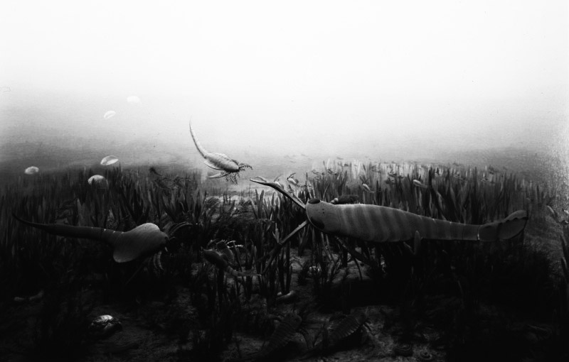
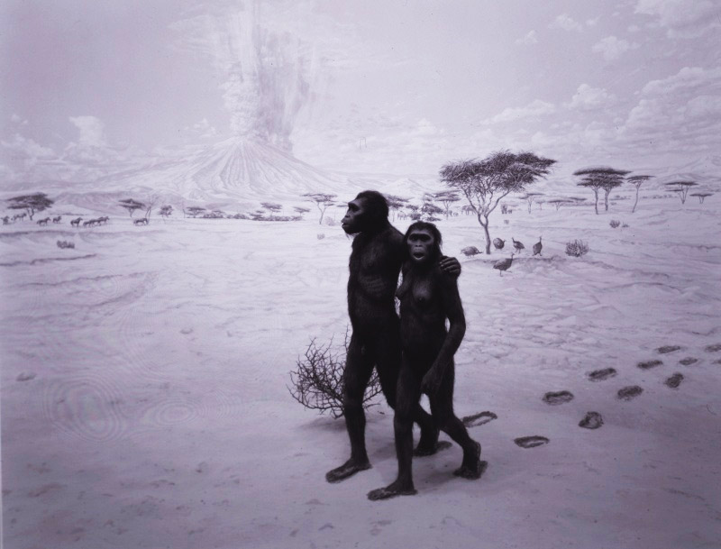
What seems clear is that the way in which a geologist becomes contemporaneous with her materials, in so far as the geological relations that bring them into being are still changing, will require new methodologies and the way these methodologies participate in the production of the present will also have to be more closely examined. In other words, the dioramas in natural history museums are serious business. In the diorama of Ordovician sea life or the “Earliest Human Relatives” photographed by Hiroshi Sugimoto, the geological past is a place of tension and drama that is filled at every moment with the differences that make it distinct from our own time [Figure 2 and 3]. Its actors strike a pose in their tableau that tells us where we are in relation to those differences, and in this way produces an image of the geological present. These realist engagements with empirical objects are always fully animated by contemporary concerns. In speculating on what a methodology for the production of the geological present would look like today, we will stay close to the venerable tradition of the diorama. Ours will be an attempt to work in this genre by taking three geological holes and their layers as the empirical objects to be animated or re-animated for the production of the geological present.
Hole #1: the forum
“There’s no need to get upset. That’s all we are, with all our obsessions. Look at what we are.”
“Yeah…”
“So much irritation in life.”
“We all fit in the same hole.”
“All of us.”
“Everyone, both rich and poor. There’s no difference.”
“Yes, there is no distinction. Luckily, or it would be too much.”
“What a thing, we live directly over bodies and don’t even know it.”
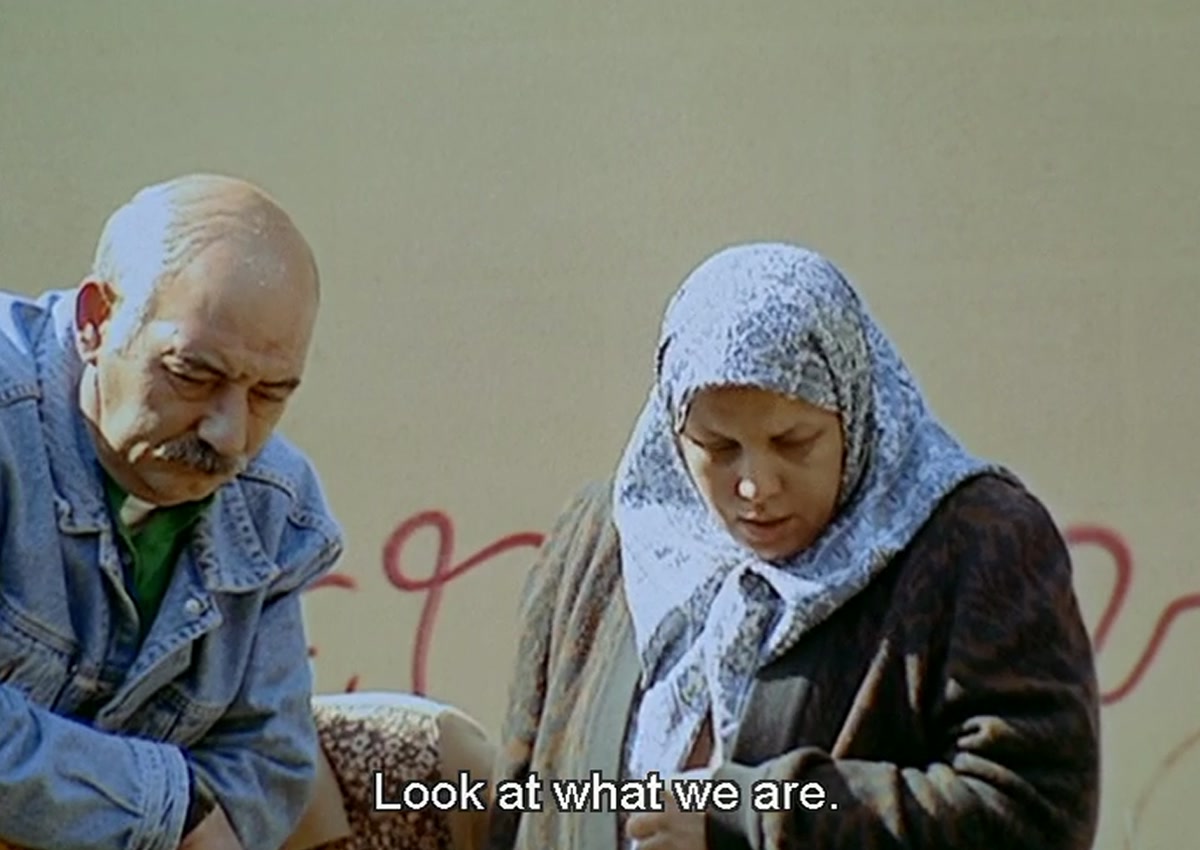
José Luis Guerín’s documentary film “En construcción” (Under Construction) begins with conversations between residents of Barcelona’s District V, also known as “El Raval,” about a hole in their neighborhood [Figure 1]. Literally, the demolition of a housing block to make way for an urban renewal project has left a large hole in the ground. Rather than being temporary, the discovery of medieval ruins at the base of the excavation has halted construction, and the hole has taken on a kind of permanence. In what seems like a strange reversal, the same demolition that promised a break with the neighborhoods past as Barcelona’s red light district, has instead produced an archeological site. Rather than looking up at the construction of the future city, Guerín documents the moment in which the residents of El Raval find themselves looking down into the bones and buildings of the former city. Everyone in Guerín’s film has a different explanation of what they see:
“To me, it’s Arabian.” “That? Arabian?”
“On TV they said it’s Roman. But who knows?”
“They used to die on the street. I remember, here in this area, during the war, they’d die right on the street.”
In these conversations the hole bears witness to an astonishing diversity of evidence, which overlap and proliferate in the chance encounters of passersby. It is a vestige of the Arabian occupation of Barcelona in the 8th century, a burial site for the “crimes committed by Spain” in the 20th century, a Roman ruin from the 6th century, a legal entity under religious law, a scientific discovery to be analyzed, a burial site for kings, a former factory, a psychic shadow of the civil war…
What Guerín is documenting is clearly not the hole as it appears in the space of the street. Aside from a few short images of skulls and stone roofs, Guerín never films the hole. Instead he places the hole between his camera and the residents of El Raval, always just out of sight. What we see instead is the hole in its capacity to produce the present. In this sense what Guerín presents us with is the moment of the holes formation: the moment in which the hole becomes this hole, rather than just another invisible moment in the process of urban renewal. The hole does this by taking on a duration5 in time, that has suddenly become capable of forensic speech through its relation to human bones.
The process by which the contours of a hole are discerned always bear this hallmark moment of recognition, which could be called its forensic recognition: the passage from something that was not presumed to have its own unique duration in time to something that suddenly does. At this moment the recognition is not only that there is a hole, but also that it was already there; that there was a hole all along: “We live directly over bodies and don’t even know it.”
Hole #2: forensic rhetoric
Guerín’s film gives us a clear image of the production of the “forum” in “forensis,” in which the production of the present through the speech of things is brought about by a proliferation of forensic sciences on the streets of Barcelona. This hole has an empirical analogue in the largest hole to have ever appeared in the 20th century, the ozone hole,6 which also came into being as a hole through the discovery of its human artifacts and unique duration: its forensic recognition [Figure 4].

To recount this history briefly, the ozone hole was discovered by three scientists from the British Antarctic Survey (BAS) who were just as surprised by the existence of this hole, currently the size of North America,7 as the general public. At the time of the discovery they were in the Arctic to improve theories of weather forecasting, rather than looking for signs of the collapse of the atmospheric preconditions for terrestrial life. The ozone data that the team recorded, even once it was plotted, still didn’t appear as a hole: it was scattered, showing no clear trend. Jonathan Shanklin, the member of the team that is credited with discovering the ozone hole, recalls presenting the same data that led to the discovery of the hole as evidence that it wasn’t there:
“The popular press was reporting at the time on studies suggesting that aerosol spray cans and exhaust gases from Concorde flights could destroy the ozone layer. Models showed, however, that the expected loss of ozone thus far was only a few per cent. I wanted to reassure the public by showing that our ozone data from that year were no different from 20 years earlier. The graph we presented to the public showed that no significant change in ozone had been detected over the years, which was true overall — but it seemed that the springtime values did look lower from one year to the next.”8
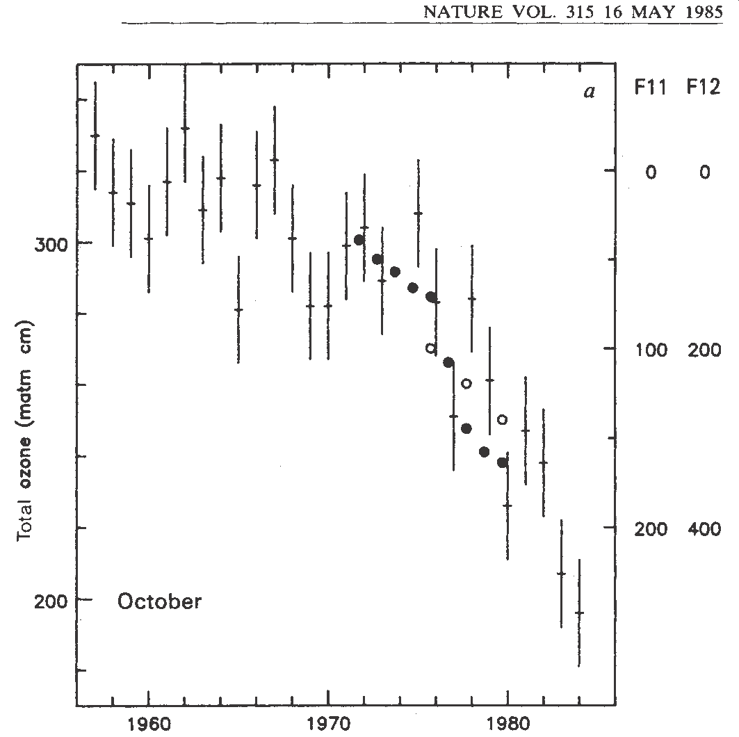
The springtime values Shanklin refers to are now called ‘the ozone hole’.9 The contours of this hole only began to take shape when the members of the team looked at these springtime values specifically, ignoring what happened in the ozone layer for the rest of the year. The ozone hole turned out to be seasonal. What the data showed was a steady decrease in the springtime ozone levels year by year, at a rate that was rapid enough to suggest the existence of a strong causal relationship. Since the work identifying CFC’s as a catalyst for ozone depletion had already been done,10 the team decided to publish an overlay of the two trends in a very unorthodox way, so as to make the image of the hole appear to the rest of the world. To do this they plotted the springtime ozone values between 1954 and 1984 on a scale that decreased from top to bottom on the graph, and then overlaid this with the chlorofluorocarbon (CFC) concentration in the atmosphere on a scale that increased from top to bottom [Figure 5].11 The combination of the two different scales, in two different orientations, produced a graph that looked for the first time like a hole and contained within it the human artifacts that gave it duration: the CFC’s. Even Shanklin seems to have been aware of the power of their forensic rhetoric:
“In retrospect, that was a really good thing to call it, because an ozone hole must be bad. Almost automatically, it meant that people wanted something to be done about it. The hole had to be filled in.”12
But why does a hole have to be filled in? It seems clear that there is something reversible about a hole. Since a hole is made, it can be unmade. This property of holes distinguishes it from gaps, in which something is just missing. Without the CFC’s, the ozone hole would just be a gap, a seasonal thinning of the ozone, in the same way that without a cemetery the hole in El Raval would just be “en construcción.” It is precisely this reversibility of holes that the American minimalist sculptor Carl Andre was describing in his famous motto: “A thing is a hole in a thing it is not.”. The distinction that Andre draws between things and holes should not be understood simply as a relation between absence and presence, as this would be the spatial relation that defines gaps. Rather, holes are always produced as “things” through a process of individuation in which a bone or chlorofluorocarbon suddenly produces the distinct duration that defines it as “not” in Andre’s axiom. In other words, duration in a hole is not produced from an absence, but from a thing that does the digging.
From the history of the production of the ozone hole, it becomes clear that the “forum” in “forensis” is just as much a place of rhetoric in the empirical sciences as on the streets of Barcelona. What also becomes clear through the work of Carl Andre is that the relation defined by a hole and its contents is simply a general description of matter itself, and in this sense the production of the material as a “thing” is the first rhetorical speech in the forum of forensics.
Hole #3: a new look at Hole #1
The hole in the neighborhood of El Raval seems to keep getting deeper: each time the bottom would appear to be in sight, another hole opens up. In this story about El Raval the soil itself did not enjoy the status of ‘thing’ until it was empirically produced in the late 19th century. The history of its production also happens to be a history of the very question that is being asked in relation to El Raval: what do the bones really reveal about the hole? Is it a human image that is discovered in the geological material of the hole, or is it the geological image that is discovered in human bones? And furthermore, what does this reveal about the present? The third hole we will now examine for its powers to produce the present through an anthropogenic geology will be the same hole as the first, but this time the forensic lens will focus on the soil itself.
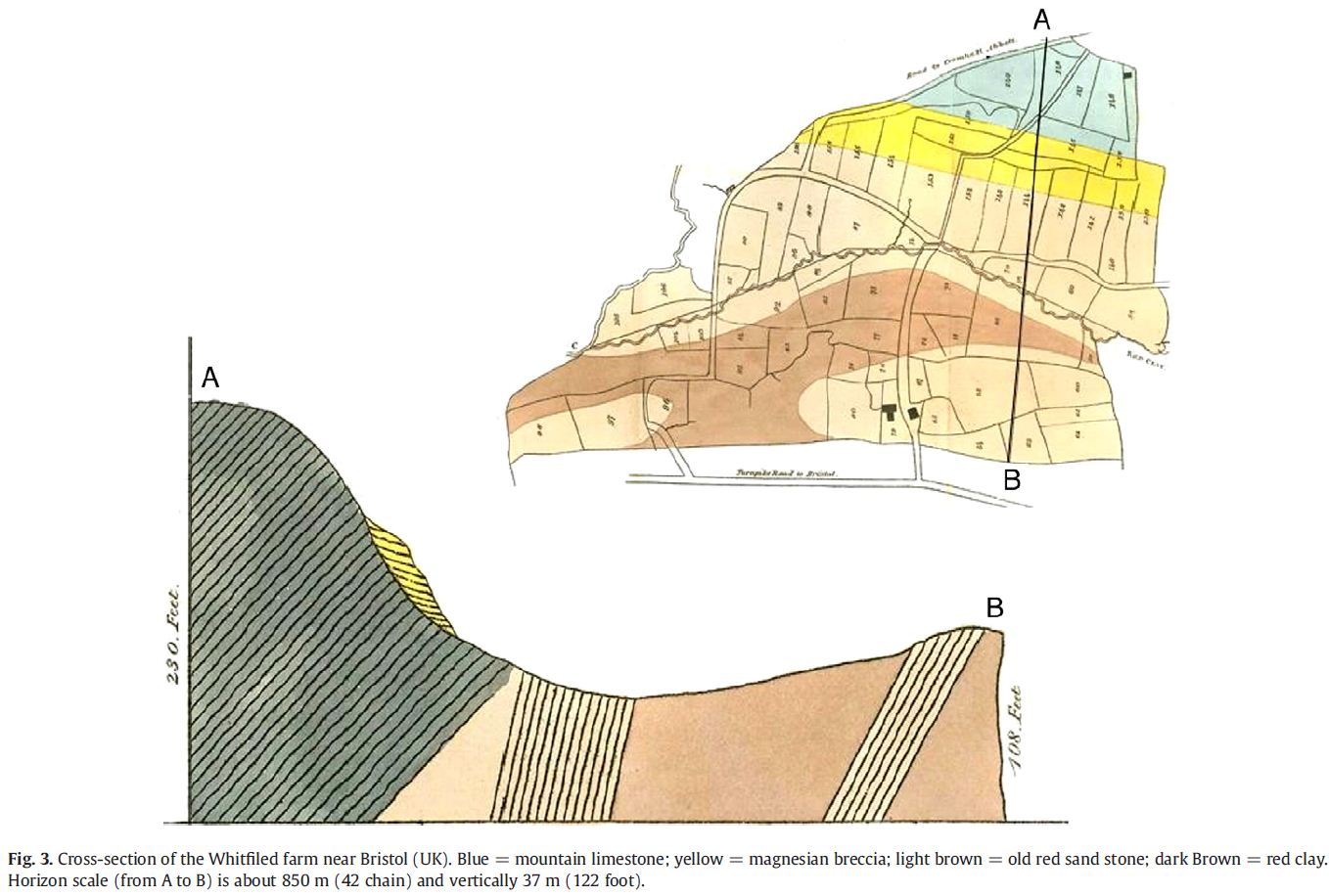
Before soil was produced empirically as a thing, it was conceptually identical to rock. In geological descriptions of rocks, the internal heterogeneity of all the elements and mineral formations is consolidated into a single term, for instance ‘granite,’ and that term then stands in for the heterogeneity of the mixture. In the stratigraphic sections of geological profiles, these heterogenous mixtures are represented as homogenous bodies so that the layers or ‘strata’ that characterize the profile can be differentiated.
The earliest 19th century texts on soil science apply this geological method directly to soil, with the understanding that soil comes from rock. An 1820 geological survey of Albany County New York elevates this understanding to the philosophical standard of common sense:
“That all the earthy part of soil consists of minute fragments of rock does not require argument, or need proof, but inspection merely to determine it. We have only to place specimens under the magnifier and their rocky origin will become manifest.”13
Giving form to this understanding of soil, John Morton’s 1843 treatise “The Nature and Property of Soils” deploys a series of drawings included in the manuscript [Figure 6].14 In these drawings the soil is depicted at the scale of geological sections, in which it appears as a thin homogenous layer at the surface of a section hundreds of feet deep. Morton’s intension in Figure 6 was to show a genetic relationship between this soil layer and the geology underneath.
In contrast, in Fallou’s later work from 1862 [Figure 7], we see the soil elevated to the status of geology itself in which the soil is not simply a sub category of its underlying rock, but is rather given the same kind of existence in time, and therefore stratographic complexity, common to rock sections. Here the alternating layers and wavy lenses that flow through the soil profile take on the capacity to be in unconformity with adjacent soil layers, which appear to have been offset from one another as if by some tectonic shift. In giving soil the status of rocks however, Fallou still denies soil its own duration separate from rocks, and therefore soil still has yet to be produced as a thing. For Fallou nothing escapes the tooth of time:
“Soil is considered to be the product of weathering, formed as the tooth of time incessantly grinds the solid covering of our planet and gradually decomposes and destroys its solid mass.”15
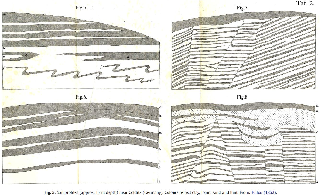
This image of soil as a kind of plaque on the tooth of time, or terminal residue of the geological destruction of the earth comes from the uniformitarian geology of the 19th century, which saw the process of erosion as a plausible theory for long-term changes in the appearance of the Earth. The image of soil in this narrative appears as the death of the rock. As rocks are given a date of birth corresponding to the historical moment they are constituted as a body, the dissolution of this body as the production of soil constitutes its empirical death as a rock. This dissolution becomes responsible for explaining the formation of soils, and is done through an analysis of the many differences in the rock’s material durations. Whereas Bergson’s sugar (see footnote 5) consisted of a single duration, rocks generally consist of multiple durations. The, sodium, potassium, and magnesium found in the feldspars and micas of granite are dissolved at different rates in contact with the climate, whereas the iron and quartz in the granite remain relatively insoluble. The tooth of time may grind incessantly, but the solid mass it chews is not uniformly affected. Soil is therefore the product of this difference that time encounters in its mastication of the Earth’s crust.
The modern, or post-mastication theory of soils begins with the idea that soil is not a residue of a process, but rather a process in itself, in which a system of layers critical to life on Earth grows out of fine rock particles. The Russian Geologist, Vasily Dokuchaev is given credit for producing the earliest comprehensive description of these layers, which he termed the soil “body”.16 What Dokuchaev is describing is the soil as a thing, in Andre’s sense, rather than a residue, which can only be studied as a postscript to some other process. That is, Dokuchaev’s soil is a thing with its own process, composed of many different parts, whose consistency as a body comes from its capacity to be recognized by a system of resemblances that repeat, and whose repetition is produced by its specific duration in time and space.
This concept of soil formation begins its story where Fallou left off. The granite that met its sad end as soil in the uniformitarian geology of the 19th century suddenly springs to life again. The tiny weathered particles of feldspar take on a new geological identity as the clay mineral kaolin. Over the course of 50 to 100+ years, the resistant quartz sand and weathered clay minerals will form kind of clay loam, and the untransformed iron in the original granite will give the soil a reddish hue. During this time it becomes a refuge for bacteria, fungi, and a diversity of soil fauna from amoebas to arthropods. These organisms fundamentally affect the structure of soil, causing the clay to form larger aggregates that have a greater capacity to resist wind erosion and retain moisture. Over time this process creates distinct layers in the soil, produced by differences in the way the soil is weathered and the work of organisms. When this process does not occur the soil is called young.17 When it does occur, it produces a repetition sufficient for the production of a system of resemblances known as soil taxonomy.
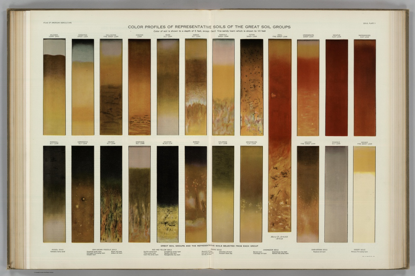

The paintings that Marbut produced for his taxonomy are an attempt to represent the new durations specific to soil and distinct from rock that had become so important to soil classification, and the production of soil as a thing distinct from rock. Marbut’s taxonomy had incorporated the insights of Dokuchaev and the Russian school by organizing all soil knowledge into the new form of the soil profile.18 Soil in this taxonomy was no longer something that could be picked up in a handful; it was something that could only be known as a system of layers between 6 and 10 feet deep created by forces of climate, parent material, relief, organisms, and time. In order to make this taxonomy visible, Marbut produced paintings, rather than photographs of the soil profile. Instead of mechanically reproducing the surface of a soil profile, these paintings attempt to produce an image of the latent diagnostic criteria of messy geological processes, like periodic inundation, in the quantifiable colors of the Munsell system.19 For Marbut and every other soil scientist at the time, these messy geological processes as they exist in relation to the production of recognizable forms in the soil profile are the proper duration of soil, distinct from the duration of rock.
At this point in the history of soil, it bears an analogous structure to that of the ozone hole in its production as a thing. Just as the CFC’s established the geological relation internal to the structure of the ozone hole (it gets bigger seasonally with CFC emissions), the production of the soil profile has established the geological relation internal to the structure of soil (it grows layers over time). Just as in the previous two holes however, the production of a material as a thing and its investment with forensic speech are processes that emerge through the many voices of the forum, and as such are rhetorical, and cosmo-political,20 rather than immutable.
According to Simonson, Marbut’s Sassafras great group would be broken up into more than 50 different soils through subsequent revisions of the USDA taxonomy.21 While each of these revisions changed the things that were said by the forensic speech of the soil, there was no fundamental revision of the way in which soil was capable of forensic speech. Such a fundamental revision to the concept of soil would remain unthinkable for almost a century, and would only come about through a reconsideration of the human relation to geological production.
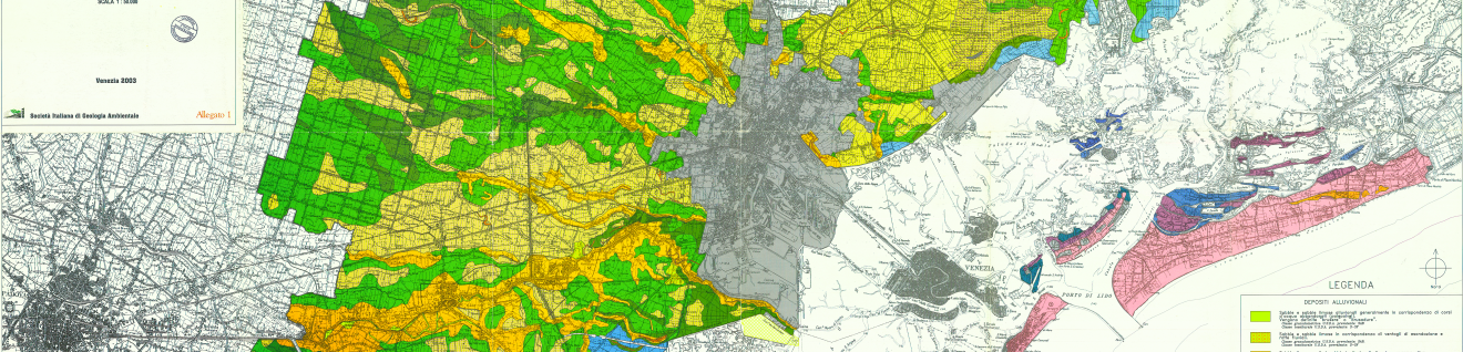
In 1995 a committee within the USDA’s National Resource Conservation Service (NCRS) was created to investigate a hole in their soil taxonomy: there was no system for classifying urban soil. In every soil map the USDA had ever made, the city limit defined the perimeter of a hole that indicated the absence of classifiable soil.22 It had taken almost a century to systematically organize the complex durations of soil into a taxonomy that was capable of taking into consideration the diverse effects of climate, plant and animal life, the slope of the ground, geologic parent material, and the scales of time relevant to each in the soil body. As the world has become predominantly urban since the 1860’s, this body has become contingent on a new set of processes. Things like trash, construction debris, coal ash, dredged sediments, petroleum contamination, green lawns, decomposing bodies, and rock ballast not only alter the formation of soil but form soil itself, and in this respect are taxonomically indistinguishable from soil. In this way the third hole in the anthropogenic geology of the present is also every hole in the soil survey that takes the shape and size of the city [Figure 9].
To illustrate the problem of inserting human bodies into the taxonomy of soil bodies more clearly, one could simply ask the question directly: what kind of soil does a cemetery make?23 In the case of a cemetery, a layer of commodities of various durations is deposited with a dense mass of organic material below the level in the soil profile at which aerobic decomposition can take place. In the United States, this amounts to roughly 30 million board feet of hardwood caskets, 104,272 tons of steel caskets, 2,700 tons of copper and bronze, and 1.8 million bodies per year.24 These bodies contain approximately 827,060 gallons of formaldehyde and 11,905 pounds of mercury, primarily from tooth fillings.25 The layer structure of the soil above this deposition is mixed into homogeneity by gravediggers or backhoes, and effectively returned to a state of youth in which the process of differential weathering is reset. In roughly 20 years the only organic material remaining will be bone, and in 30 to 40 years a wooden coffin will also break down, leaving a thin and distinct layer of organic material and commodities in the profile. The average amount of mercury in a human body will remain in the soil for around 2,600 years, whereas the formaldehyde will break down in first few years of decomposition. In other words the layer structure that forms the profile of cemetery soil has a set of complex material durations that change and, as is evident from El Raval, will be clearly diagnostic of a recognizable soil structure for thousands of years.
Among the most common soils to repeat throughout the city are soils that form in construction debris. The basic metabolic functions of construction and demolition in urban areas produce a huge amount of waste material in the form of concrete, asphalt, brick, masonry blocks, drywall, steel, rebar, ceramic, etc… This material is expensive to remove and so it is mixed with fill or simply buried. Like the soil sediment deposited by rivers, the building materials mixed into the soil create a clear geographical and even architectural specificity to the soil. In this sense the soil and the city are mirror images of each other, not only in the negative image of extraction as has often been pointed out, but also in the positive image of deposition.
The forensic muteness of soils in urban areas is all the more strange for this reason, that the richness of the material relations it has the capacity to speak of come from its geologic reciprocity with the city. The reason for this muteness is clear enough however, as present day descriptions of soil date to the original geological relations used to define soil against rock. It also comes from the lack of interest in these urban processes, as the usefulness of all soil knowledge has historically been defined through its relation to agriculture.
The United States Department of Agriculture’s recent interest in urban soils comes out of precisely this same concern for the usefulness of soil knowledge: soil is an infrastructure that no city can afford to live without. The most common reasons for a city to be interested in its soils are:
- subsidence, or the dewatering or decomposition of organic soils which causes the city to sink.
- filtration, or the general property of soils to filter pollutants that might otherwise contaminate the city’s water supply
- infiltration, or the capacity of soils to detain and retain water, which takes pressure off of the urban sewer and water infrastructure
- structural function, or the properties of soil that support roads, bridges, buildings, slopes, levees or any other structure that meets the ground.
- fertility, or the capacity of the soil to sustain plant life in parks, road medians, wetlands, river corridors, or on steep slopes.
The urban processes that produce new kinds of soil matter to organizations like the USDA because they change these useful properties of the soil. Traditionally the useful properties of soil were each understood through their own taxonomy; for instance, every soil’s usefulness for road building was given a rating on a uniform scale. With each new useful property of soil came another taxonomy, in which all soils were classified once again according to this property. Without taxonomic criteria specific to the soil horizons made by urban processes however, the possibilities for understanding how soil is made in cities did not exist, and neither did the soil itself, as it once again it lost its duration in time to the useful property that organized it.
Recently the City of New York has taken a different approach, in an effort to understand the useful properties of its soil in relation to the real soil horizons produced by urban processes. This involved digging a lot of holes and describing the, at times, bizarre results. The USDA has discovered for example that “Fishkill” soil, which “has formed in a thick mantle of industrial ‘fly ash’ mixed with demolished construction debris,” is “good” for use as wildlife habitat for freshwater wetland plants.26 The “typical soil profile” for Freshkills Landfill, also now included on the map, consists of 30 to 80 inches of “extremely cobbly sandy loam” which is “20% cobble-size biodegradable artifacts, 45% cobble-sized non-biodegradable artifacts, and 5% cobbles.” Its Soil Taxonomy classification is “Coarse-loamy, mixed, active, hyperthermic Typic Dystrudepts.” Classifying Freshkills Landfill in the great group “Dystrudept,” means that it is dystrophic (infertile for agriculture), udic (moisture regime), and of the order Inceptisol, meaning it has poorly developed subsurface horizons. These subsurface horizons are up to 75% trash. Classifying Freshkills landfill as an Inceptisol brings the USDA to the curious conclusion that this soil has a lot in common with forests on the steep slopes of North Carolina’s Appalachian Mountains. What better diorama of the emerging geology of the present could be produced? The convergence of mountains of trash and piedmont mountains in the USDA’s taxonomy is a convergence of resemblances, in which the geological relation of newness, with respect to processes of soil formation, is privileged over the difference between trash (humans) and mountains (nature). Each of these soils is subject to very rapid and powerful forces of deposition and removal which result in a young soil (Inceptisol), that is infertile. In this description there is both an understanding of soil as a system of layers, and as a useful thing, produced by an analysis of geologic relations, rather than anthropocentric descriptions of geological origins. This focus on geological relations assumes that all mater is geological, insofar as it has a duration in time, and that this duration is produced in the forum of forensics, called taxonomy. The practical necessity of mapping the surface geology of cities has clearly led to a deeper understanding of the stratigraphic relations between human beings and the geological present. Understanding the extent to which patterns of urbanization, domesticity, burial, recreation, architecture, horticulture and warfare are factors of soil formation produces a new set of possibilities for the production of the geological present. As both a historical archive and a living body, soil exists at precisely that interval between the geological past and future that is bracketed by the term “Anthropocene,” and as a material that is in direct reciprocal relation to all the material processes that define daily life, it constitutes an immense forum and an immense hole, around which a lot of things could be said about the present, if only in passing.
Bibliography
- Berlant, Lauren. Cruel Optimism. Durham: Duke University Press, 2011.
- Charzyński, Przemysław, Renata Bednarek, and Beata Solnowska. "Characteristics of the soils of Toruń cemeteries." 19th World Congress of Soil Science, Soil Solutions for a Changing World. Brisbane, Australia, 2010.
- Crutzen, Paul J. Nobel Lecture: My Life with O3, NOx and Other YZOxs. n.d. http://www.nobelprize.org/nobel\_prizes/chemistry/laureates/1995/crutzen-lecture.html (accessed 10 24, 2012).
- Darwin, Charles R. Earthworms and vegetable mould. London, 1881.
- Dokuchaev, V Vasily. "Tchernozeme (terre noire) de la Russie D'Europe." Societe Imperiale Libre Economique. (Imprimeric Trenke & Fusnot), 1879.
- Eaton, A, and T R Beck. "A Geological Survey of the County of Albany." Agricultural Society of Albany County, New York, 1820.
- Fallou, F A. Pedologie oder Allgemeine und besondere Bodenkunde. Dresden: Schoenfeld, 1862.
- Farman, J C, B G Gardiner, and J D Shanklin. "Large losses of total ozone in Antarctica reveal seasonal ClOx/NOx interaction." Nature 315 (5 1985): 207-210.
- En construcción (Under Construction). Directed by José Luis Guerín. 2001.
- Harker, Alexandra. "Landscapes of the Dead: an Argument for Conservation Burial." Berkeley Planning Journal 25, no. 1 (2012).
- Hart, A, and S Casper. Potential groundwater pollutants from cemeteries. Environment Agency, Science Report, 2004.
- Hartemink, Alfred E. "The depiction of soil profiles since the late 1700s." Catena 79 (06 2009): 113-127.
- Marbut, Curtis F. “Color Profiles of Representative Soils of the Great Soil Groups.” In Atlas of American Agriculture: Physical Basis including Land Relief, Climate, Soils, and Natural Vegetation of the United States, by Oliver E Baker, Plate 3. Washington DC: United States Government Printing Office, 1936.
- Morton, John. The Nature and Property of Soils, 4th ed. London, 1843.
- NASA Ozone Watch. Ozone Hole Watch. National Aeronautics and Space Administration Goddard Space Flight Center. 9 7, 2011. http://ozonewatch.gsfc.nasa.gov (accessed 10 23, 2012).
- New York City Soil Survey Staff. New York City Reconnaissance Soil Survey. Soil Survey, Staten Island NY: United States Department of Agriculture Natural Resources Conservation Service, 2005.
- Orth, A. Die geognostisch-agronomische Kartirung. Berlin: Verlag von Ernst & Korn, 1875.
- Shanklin, Jonathan. "Reflections on the ozone hole." Nature 465 (5 2010): 34-35.
- Shanklin, Jonathan, interview by United Nations Environment Programme (UNEP) Division of Technology Industry and Economics (DTIE). The Antarctic Ozone Hole: From Discoverty to Recovery, a Scientific Journey (2011).
- Simonson, Roy W. Concept of Soil. Vol. 20, in Advances in Agronomy, by A G Norman, 1-47. Academic Press, 1968.
- Stengers, Isabelle. Cosmopolitics I. Minneapolis: Minnesota Press, 2010.
- Tandarich, John P, Robert G Darmody, Leon R Follmer, and Donald L Johnson. "Historical Development of Soil and Weathering Profile Concepts from Europe to the United States of America." Soil Science Society of America 66, no. 2 (March-April 2002).
- Weizman, Eyal. Forensic Architecture: Notes from Fields and Forums. Series: dOCUMENTA (13): Notizen - 100 Gedanken No. 062, 2012.
Footnotes
-
Weizman, Eyal. Forensic Architecture: Notes from Fields and Forums. Series: dOCUMENTA (13): Notizen - 100 Gedanken No. 062, 2012. ↩
-
The damming of rivers has produced a measurable alteration of the speed of the rotation of the Earth. For an excellent primer on the city as a geologic force, see Smudge Studio’s Geologic City: a Field Guide to the GeoArchitecture of New York. ↩
-
The “Anthropocene” was a term coined by atmospheric chemist Paul Crutzen and ecologist Eugene Stoermer (independently) to recognize human beings as the producers of the geological sign under which all other geological processes on Earth would fall, and be recognized as contemporaneous with, in the geology of future epochs. Its adoption by the International Commission on Stratigraphy (ICS) would mean the end of the current geological epoch: the Holocene. ↩
-
For Berlant, “Emergency is another genre of the present.” Pg. 294N14, and 4. Berlant, Lauren. Cruel Optimism. Durham: Duke University Press, 2011. For an account of the construction of the historical present see Chapter 2: Intuitionists. ↩
-
The use of the term “duration” as a property attributable to things comes from the French philosopher Henri Bergson. In Bergson’s 1907 text “Creative Evolution,” he observes that the only thing that distinguishes ‘sugar’ among other forms of matter in the universe is that it makes him wait. That is, his idea of sugar doesn’t come from its shape or the space it takes up as a volume, but rather from the unalterable duration of time it takes for the sugar to dissolve in his glass, which he must live, and in this case, experience as impatience. Sugar is a duration that he has to mix with the duration of his own finite life. The usage of the term duration in this text will refer to the property of a thing having an existence in time. ↩
-
Ozone is what atmospheric chemists call “odd oxygen,” or O3 . When odd oxygen loses its third oxygen atom to become O2, it is no longer ozone, and ceases to perform the functions associated with ozone, like protecting the Earth from ultraviolet radiation. Chlorine, known for being among the most reactive elements on the periodic table, is a powerful catalyst for the reaction that breaks O3 down into O + O2. The result of this process is not only the breakdown of O3, but also the liberation of the same cholorine atom that initiated the reaction. This leaves it free to begin the reaction again with another ozone molecule, and as such, creates a chain reaction in the stratosphere in which a single element of chlorine can convert huge amounts of ozone. The set of equations that explain this earned its scientists the Nobel Prize, but oddly enough, it didn’t lead to the discovery of the ozone hole. The problem was understanding how it is even possible for an element as highly reactive as chlorine to ever reach the stratosphere, after passing through more than 20 kilometers of atmosphere from the surface of the earth. This anthropogenic chemistry turned out to involve some extremely beautiful and very rare high altitude clouds, called nacreous or polar stratospheric clouds, whose icy surface provides a site for chemical reactions. This was not understood until after the ozone hole’s discovery. ↩
-
2011 ozone hole recorded average between September 7 and October 13 = 24.7 million square kilometers. Source: NASA Ozone Watch, Ozone Hole Watch, National Aeronautics and Space Administration Goddard Space Flight Center, 9 7, 2011, http://ozonewatch.gsfc.nasa.gov (accessed 10 23, 2012). ↩
-
Shanklin, Jonathan. "Reflections on the ozone hole." Nature 465 (5 2010): 34-35. ↩
-
Spring in the southern hemisphere is from September to November. ↩
-
Paul J. Crutzen, the inventor of the term “Anthropocene,” shared the Nobel Prize for this work in 1995. See: Crutzen, Paul J. Nobel Lecture: My Life with O3, NOx and Other YZOxs. Nobelprize.org. ↩
-
Farman, J C, B G Gardiner, and J D Shanklin. "Large losses of total ozone in Antarctica reveal seasonal ClOx/NOx interaction." Nature 315 (5 1985): 207-210. ↩
-
Jonathan Shanklin, interview from documentary, The Antarctic Ozone Hole: From Discovery to Recovery, a Scientific Journey, United Nations Environment Programme (UNEP) Division of Technology Industry and Economics (DTIE), 2011. The film was produced as part of the UNEP’s work program under the Multilateral Fund for the Implementation of the Montreal Protocol, www.unep.org/ozonaction. ↩
-
Eaton, A, and T R Beck. "A Geological Survey of the County of Albany." Agricultural Society of Albany County, New York, 1820. ↩
-
Morton, John. The Nature and Property of Soils, 4th ed. London, 1843. ↩
-
Fallou, F A. Pedologie oder Allgemeine und besondere Bodenkunde. Dresden: Schoenfeld, 1862. ↩
-
There is some dispute as to what precisely to credit Dokuchaev with. Tandarich et. al. (see below) argue that that Orth’s 1875 manuscript Die geognostisch-agronomische Kartirung contained the soil profile concept in the term “boden-profil.” In Dokuchaev’s 1879 publication, he used the terms “zaleganiya chernozem,” (stratification of the chernozem) and “stroenie chernozem” (structure of the chernozem) to describe the soil profile. His descriptions of the soil as a body do not appear until his major work Russian Chernozem (1883), in which cites both Orth and Fallou as having influenced his own thinking. However, it was in this work that Dokuchaev published his famous ABC system for soil profile layers, which is still in use today. The biologist and evolutionary theorist Charles Darwin also published an ABC system of soil layers in his book on earthworms in 1881, which contained detailed drawings of the soil layers. See: Charles Darwin, Earthworms and Vegetable Mould (London, 1881); Vasily, Dokuchaev, Tchernozeme (terre noire) de la Russie D’Europe, Societe Imperiale Libre Economique (Moscow: Imprimeric Trenke & Fusnot, 1879); A. Orth, Die geognostisch-agronomische Kartirung (Berlin: Verlag von Ernst & Korn, 1875); and John P. Tandarich, Robert G. Darmody, Leon R. Follmer and Donald L. Johnson, “Historical Development of Soil and Weathering Profile Concepts from Europe to the United States of America,” Soil Science Society of America 66, no. 2 (March-April 2002): 335–346. ↩
-
This is known as the “pedological age” of soil, which refers to the amount of weathering, and therefore layer formation that the soil has undergone. Weathering is most rapid where there is an abundance of water and heat. Therefore soils in the tropical rainforest tend to be pedologically old, whereas soils in the arctic are forever young. Sand dunes are also among the youngest soils. ↩
-
Marbut was a keen reader of Russian soil science, and considered it to be far more advanced than American soil research at the time. He was particularly influenced by Dokuchaev’s student Konstantin Glinka, whom he personally translated into English. ↩
-
The Munsell system is a taxonomy for the classification of colors that was adopted by the USDA under Marbut for the specification of soil color. It’s great groups are hue, value, and chroma, which form the axes of a three dimensional color space that can be used to locate colors perceptible to the human eye. For example, 2.5YR 4/3 would specify a reddish brown. ↩
-
Isabelle Stengers develops the idea of cosmo-politics in a three volume work by that title. For Stengers, atomic particles like the neutrino participate in the production of the present through the cosmological commons they create: “The neutrino is not, therefore, the ‘normal’ intersection between a rational activity and a phenomenal world. The neutrino and its peers, starting with Newton’s scandalous force of attraction, bind together the mutual involvement of two realities undergoing correlated expansions: that of the dense network of our practices and their histories, that of the components and modes of interaction that populate what is referred to as the ‘physical world.’ In short, the neutrino exists simultaneously and inseparably ‘in itself’ and ‘for us,’ becoming even more ‘in itself,’ a participant in countless events in which we seek the principles of matter, as it comes into existence ‘for us,’ an ingredient of increasingly numerous practices, devices, and possibles.” “If something is to be celebrated or must force others to think, it is not the neutrino but the coproduction of a community and a reality of which, from now on, from the point of view of the community, the neutrino is an integral part.” See: Stengers, Isabelle. Cosmopolitics I. Minneapolis: Minnesota Press, 2010. ↩
-
Simonson, Roy W. Concept of Soil. Vol. 20, in Advances in Agronomy, by A G Norman, 1-47. Academic Press, 1968. ↩
-
There are four soil surveys in the history of the USDA which attempt to map a city: The Soil Survey Report of Washington, DC (Smith 1976), Soil Survey Report of St. Louis County (Benham, 1982), Soil Survey Report of Montgomery County (Brown and Dyer, 1985), and Soil Survey Report of the City of Baltimore (Levine and Griffin, 1998). In each of these surveys, the soil is described in very broad terms such as “urban land,” “human-made,” or “disturbed,” without any reference to the soil profile of these urban soils. Without the soil profile, soil is returned to its origins as geology. ↩
-
For an excellent paper on the soil a cemetery makes, see: Przemysław Charzyński, Renata Bednarek and Beata Solnowska, “Characteristics of the Soils of Toruń cemeteries,” (paper presented at the Nineteenth “World Congress of Soil Science, Soil Solutions for a Changing World,” Brisbane, Australia, 2010). ↩
-
All figures from: Harker, Alexandra. "Landscapes of the Dead: an Argument for Conservation Burial." Berkeley Planning Journal 25, no. 1 (2012). ↩
-
Mercury figures from: Hart, A., Casper, S., 2004. Potential groundwater pollutants from cemeteries. Science Report, December 2004. Environment Agency ↩
-
All soil descriptions from: New York City Soil Survey Staff. New York City Reconnaissance Soil Survey. Soil Survey, Staten Island NY: United States Department of Agriculture Natural Resources Conservation Service, 2005. ↩