In cities, soil comprises a blurry category whose boundaries are both empirically uncertain and politically contested. By considering the specific material and political conditions of the world's largest wastewater agricultural system, Thinking Through Soil: Wastewater Agriculture in the Mezquital Valley offers a design methodology derived through a sustained engagement with Mexico's most controversial soil, and imagines what a better environmental future might look like in central Mexico. This case study demonstrates a way to "think through soil" in urban areas —to privilege soil as the basis for decision-making in city planning and design— and asserts an approach to soil knowledge with global utility, particularly for places where environmental problems are complex, long-term, and have no purely technical solution.
Info
Authors
- Montserrat Bonvehi Rosich
- Seth Denizen
Press
- Harvard Design Press
Date
- 2025
"Luna salió de su casa de agua para iluminar el cielo. Quiso distribuir sus blancos destellos en el firmamento, y defecó. Se esparcieron sus heces, piedras brillantes sobre la negrura."
— Alfredo López Austin, Una Vieja Historia de la Mierda
Thinking Through Soil: Wastewater Agriculture in the Mezquital Valley

Book Excerpt
Landscapes of the CSO
No other city in the world has tried to do as much to re-use the combined sewer as Mexico City. Consider, for example, some of the basic geographical assumptions that a combined sewer system typically makes. The idea of a combined sewer is to use freshwater to flush concentrated waste into a large water body. This assumes that there is a water body, like an ocean, that is large enough to dilute the waste indefinitely. It also assumes that if the sewer system is far away from this water body there is a river to convey the waste. The river should not be seasonal and should always maintain the minimum flow-rate necessary to convey the waste. Its flood stages should also never exceed the topographic level of the combined sewer pipes themselves, which implies a certain spatial relationship between river and city. In short, there is a vast imaginary landscape contained in the concept of a combined sewer system, and this landscape bears almost no resemblance to Mexico City.
From the perspective of a combined sewer system, Mexico City has no rivers. Topographically, it sits in the bottom of a bowl, or what geomorphologists call an “endorheic basin.” For the last 700,000 years this bowl has been accumulating water in a large lake system that has no outflow. In the 16th century, the city’s lakes stretched continuously over 2000 square kilometers in the rainy season.1 During the dry season the waters would partially recede, creating shallow marshes along its borders, revealing the blurry outlines of five separate lakes. From North to South, they were: Zumpango, Xaltocan, Texcoco, Xochimilco, and Chalco. The towering volcanic mountain ranges to the south put the city in their rain shadow, capturing fresh water from storms that blow in from the Gulf. When the lakes existed, this rainfall differential created a salinity gradient in the lake-water. The three northern lakes were brackish from the accumulation of soluble salts produced by the weathering of volcanic rocks for more than 700,000 years. The southern lakes (Chalco and Xochimilco) were fresh, as the rain-water from these southern slopes pushed the saline waters north towards the bottom of the basin. In the mid-15th century, the Aztec ruler Nezahualcoyōtl built a dike through the middle of the lake system. Its primary function was flood control but, like all good infrastructure it was multifunctional and also worked to preserve this salinity gradient, ensuring that the southern lakes could be used as a freshwater reservoir for crop production. The famous “chinampas” of Xochimilco took advantage of this and were, at one time, able to produce food for two hundred thousand people in Mexico City.2 For centuries, these southern lakes were the breadbasket of the city, whose fish, corn, chili, beans, and squash were easily floated on boats to its bustling urban markets. The saline waters of Texcoco were also productive, and provided a nutritious algae (spirulina), salt harvesting (tequesquites), the “caviar” of the waterfly (axacayácatl), and abundant waterfowl.3 As an important resting place on the Central Americas Flyway, the brackish wetlands of Texcoco were full of migratory birds.

These dynamic hydrological cycles were precisely what colonial engineers struggled to disrupt in the 16th century aftermath of colonization. The seasonal flooding that produced a perpetually blurry boundary between the city and its muddy wetland periphery was particularly appalling to the arid Iberian imagination.4 Early European hydrological efforts focused on draining Lake Zumpango, which is topographically the highest in the cascade of lakes that end in the bottom of the basin near the center of Lake Texcoco. By controlling water levels in Zumpango, the idea was to deprive Lake Texcoco of floodwater. To do this, colonial administrators decided to build a 20 kilometer long, 60 meter deep trench through the topographic walls of the Basin called El Tajo de Nochistongo (the Nochistongo Cut), which began in 1607 and continued, off and on, for two centuries. The project was notorious for its cruelty and completed mostly through forced indigenous labor. The historian Vera Candiani notes that workers were lowered into the trench on ropes to dig out the walls in something called “the Indian-dangling” method, earning it the name El Tajo de las Desgracias (The Trench of Misfortunes).5 The Mezquital Valley is what lies on the other side of this trench (see Mexico Mezquital Basin Map).
By the 19th century it became apparent that El Tajo de las Desgracias would never be able to solve Mexico City’s flooding problem, and a new plan was formed. Instead of cutting a steep trench through the soft and erodible soils of the Basin, a tunnel would be constructed. This new tunnel would connect Mexico City’s San Lazaro neighborhood to the Mezquital Valley through the Gran Canal del Desagüe.6 Inaugurated by Porfirio Díaz in 1901, the drainage canal was a symbol of progress and modernity for Mexico City at the dawn of the new century.7 After hundreds of years of failure, it was a marvel of engineering that finally broke through the basin walls whose topography had determined everything about life in the lacustrine city. However, what had started in the 17th century as a project to mitigate flooding had ended in 1901 as something very different. The Gran Canal would not only carry floodwater during the rainy season but it would also harness the power of Mexico City’s remaining freshwater lakes in the south (Chalco and Xochimilco) to flush Mexico City’s sewage north to the Mezquital Valley.8 In this way, the Gran Canal was the origin of Mexico City’s combined sewer system, and it transformed the Mezquital Valley into a CSO (Combined Sewer Overflow).
The architect of his plan was a drainage engineer named Roberto Gayol, and his expertise was critical to the project. Without sufficient rainfall to move the sewage, Gayol needed to figure out how to use the lakes to create baseflow. For this reason, Gayol argued passionately in favor of a combined sewer system rather than a divided one. Without some kind of force pushing the waste out of the city the system would stagnate, and a combined sewer maximized that force. According to Gayol’s calculations in 1892, Lake Chalco and Xochimilco could provide 2,500 liters per second through the Canal de la Viga.9 This effectively turned the lakes into a massive flush tank that sat above every urban toilet in Mexico City. The volume of wastewater Mexico City sent to the Mezquital was significant enough, and dilute enough, that in these early days the first idea for how to use Gayol’s 2,500 liters per second wasn’t even agriculture. The first wastewater canals to be built in the Mezquital were designed to find the valley’s steepest topographic gradients for powering hydroelectric generators, and this historical anachronism explains much of the unusual complexity of the wastewater irrigation canal network today.
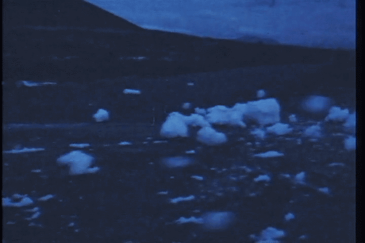
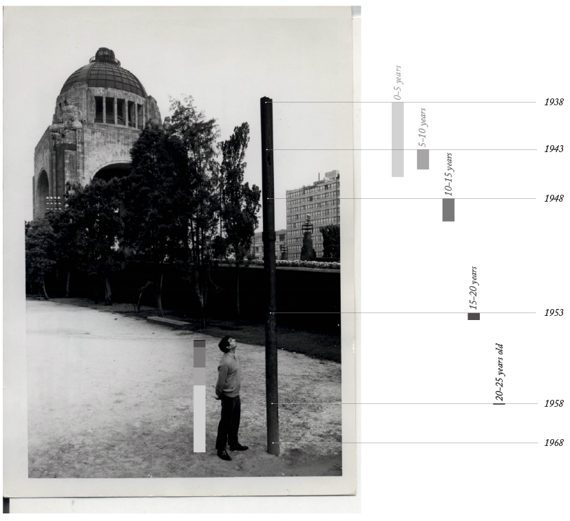
In hindsight, it is remarkable that nowhere in Gayol’s 156 page proposal does he consider the possibility that this water source might disappear. Those 2,500 liters a second were supposed to last forever in the plan he outlined. Today, what remains of Lake Xochimilco is less than 1% of what it was in 1892, and its waters have been fully converted into sewage infrastructure (also a World Heritage Site). Lake Chalco disappeared entirely, but has started to return as a battery of groundwater extraction wells caused enough subsidence for parts of the city to sink below the water table again, creating a ghostly and garbage-filled memorial to the former lake.10 In other places, this water table has been lowered as much as 100 meters below levels recorded in the early 20th century, and it continues to fall to the profound disappointment of the 22 million people in the capital city who depend on the Basin’s subsurface aquifers for 70% of their drinking water, and who must live in the perpetual aftermath of the urban land subsidence this groundwater extraction causes. Over the next 150 years, Mexico City is expected to fall between 60 and 90 feet.11 This rate of collapse is locked in from the desiccation of its upper aquitard, and cannot be reversed even if the city were to stop pumping, or pump water back into the ground. As different parts of the city fall at slightly different speeds, subsurface infrastructure will continue to break, making the city’s plumbing problems endless and unfixable. Lake Texcoco, which was once a biodiverse saltwater marsh, is now a barren plain capable of supporting only the most salt tolerant plant species, like Distichlis spicata and salt cedar, Tamarix ramosissima.12 Instead of threatening the city with floods during the rainy season between June and November, it threatens the city with dust storms in the dry winter months between January and May.13
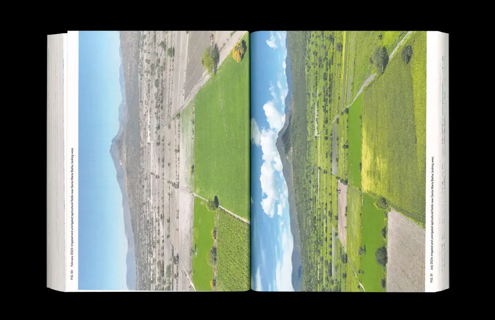
The Mezquital Valley by contrast has become a verdant agricultural landscape that supports three crops a year.14 Mexico City’s sewer system sends it more water than many of Mexico’s major rivers would provide —an average of about 60 cubic meters per second over the course of a year. This is more than the Río Baluarte that forms the border between Durango and Sinaloa, and about a third as much as the Rio Bravo (aka the Rio Grande) on the border with Texas.15 New springs, lakes, and streams still regularly appear in the Mezquital Valley, and in this sense, we can see its 20th century history as a long process of hydrological transfer. The southern lake system that supported Mexico City’s agricultural production for thousands of years disappeared, only to re-emerge as lakes, springs and aquifers 100 kilometers away in the world’s largest wastewater agriculture system in the Mezquital Valley.
From this perspective, Mexico City’s combined sewer is unique. Where many city’s produce only a small pause in the hydrological journey of a rain-drop from cloud to ocean, Mexico City is both journey and destination. Every drop of rain that falls in the Basin of Mexico stays there, unless it is managed by built infrastructure that moves that water somewhere more convenient. For cities like Paris and London, whose physical geography closely resembles the imaginary landscape implied by a combined sewer system, this process is powered by the force of gravity. For Mexico City, the entire imaginary landscape assumed by a combined sewer system did not actually exist and had to be built at great cost according to its implicit geographical imperatives.
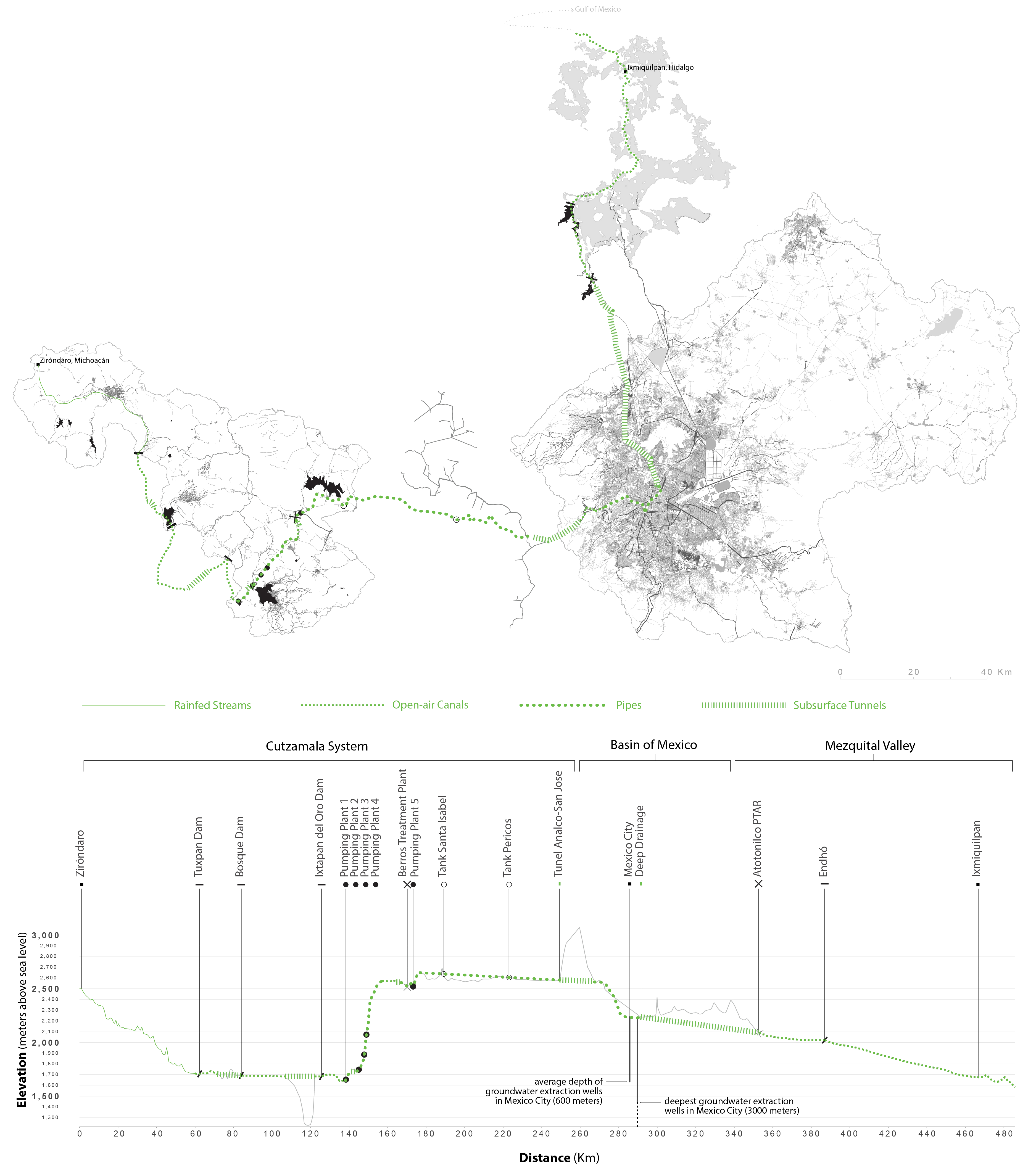
The infrastructure for containing water and moving it around the city during rainfall events is massive, but it’s also only part of the system. Today, 30% of Mexico City’s water comes from pipelines beginning in the upper Lerma and Cutzamala Basins, which is topographically a kilometer below the city. Water flows from these basins through a 127 kilometer aqueduct before being pumped upwards, 1.2 kilometers in altitude, to enter the Basin of Mexico. This involves a vast network of canals, 3 pipelines, 11 dams, 6 pumping plants, 10 reservoirs, and 6 storage tanks.16 It then provides municipal water to residents before entering the combined sewer system and traveling another 80 kilometers to the Mezquital Valley in the Drenaje Profundo, or “deep drainage” system 100 meters below ground. The other 70% of Mexico City’s water comes from groundwater pumps within the Basin of Mexico, which extract water from as deep as 2 kilometers below the city.17 On an average day, the combined sewer system needs to move 60 cubic meters of water per second, and while some of this water is rain that just recently fell on the city or its adjacent basins, 70% of it is rain that fell hundreds of thousands of years ago.

To call the result a combined sewer system is therefore to risk underselling the immensity of what was actually built over the last 500 years. The Mexican Architect Iñaki Echeverria refers to the system as “a leviathan.” The city’s famous sewer line diver, Julio César Cu, describes it as something like “outer space.”18 For the Mexican television drama Drenaje Profundo (Deep Drainage), it’s a vast underground laboratory where the government researches immortality drugs to test on students who disappeared in the 1968 Tlatelolco massacre. None of these descriptions should be read as hyperbole. In each case, they capture something precise and accurate about the combined sewer, if we understand it in the above sense, as an inherently speculative project to build a landscape that spatially and temporally inverts the city’s physical geography in order to bury the evidence of an old colonial crime beneath cleaner and more sanitary streets. It would be science fiction if it hadn’t been built.
Footnotes
-
Sanders, William T., Jeffrey R. Parsons, and Robert S. Santley. The Basin of Mexico: The Ecological Processes in the Evolution of a Civilization. Studies in Archaeology. New York: Academic Press, 1979. ↩
-
Chinampas are a network of agricultural plots of land formed by a process of placing dredged sediments from shallow canals on the land surface to cycle nutrients and maintain soil moisture. Parsons, Jeffrey R., Mary Parsons, Virginia Popper, and Mary Taft. “Chinampa Agriculture and Aztec Urbanization in the Valley of Mexico.” Prehistoric Intensive Agriculture in the Tropics, 232 (1985): 49–96. ↩
-
Parsons, Jeffrey R. “The Pastoral Niche in Pre- Hispanic Mesoamerica.” In Pre-Columbian Foodways: Interdisciplinary Approaches to Food, Culture, and Markets in Ancient Mesoamerica, edited by John Staller and Michael Carrasco, 109–36. New York: Springer New York, 2010.; See also Ruiz de Velasco, Tomas. “Los Tequesquites Del Lago Texcoco.” Revista Mexicana de Ingeniería y Arquitectura 4, no. 5 (May 15, 1926). ↩
-
On the European distaste for wetlands, see McLean, Stuart. “BLACK GOO: Forceful Encounters with Matter in Europe’s Muddy Margins.” Cultural Anthropology 26, no. 4 (2011): 589–619. ↩
-
Candiani, Vera S. Dreaming of Dry Land: Environmental Transformation in Colonial Mexico City. Stanford, CA: Stanford University Press, 2014. ↩
-
Graham, Johns Webb. “Environmental, Social, and Political Change in the Otomí Heartland: A Hydraulic History of the Ixmiquilpan Valley (Hidalgo State, Mexico).” PhD thesis, Yale University, 2018. ↩
-
Agostoni, Claudia. Monuments of Progress: Modernization and Public Health in Mexico City, 1876–1910. Latin American and Caribbean Series, 4. Calgary: University of Calgary Press, 2003. ↩
-
Graham, Johns Webb. ibid; Tortolero Villaseñor, Alejandro. Tierra, agua y bosques: historia y medio ambiente en el México central. 1. ed. Colección Ecología (Mexico City, Mexico). Ciudad de México: Centre Français d’Études mexicaines et centraméricaines and Instituto de Investigaciones Dr José María Luis Mora, 1996. ↩
-
Gayol, Roberto. Proyecto de desagüe y saneamiento para la Ciudad de México. México: Oficina Tip. de la Secretaría de Fomento, 1892. ↩
-
Alves, Maria Thereza. El Regreso de Un Lago / The Return of a Lake. Cologne, Germany: Verlag der Buchhandlung Walther König, 2012; Ortiz Zamora and Ortega Guerrero, “Origen y Evolución de Un Nuevo Lago En La Planicie de Chalco: Implicaciones de Peligro Por Subsidencia e Inundación de Áreas Urbanas En Valle de Chalco (Estado de México) y Tláhuac (Distrito Federal).” Investigaciones Geográficas 64 (2007): 26–42. ↩
-
Chaussard, E., E. Havazli, H. Fattahi, E. Cabral-Cano, and D. Solano-Rojas. “Over a Century of Sinking in Mexico City: No Hope for Significant Elevation and Storage Capacity Recovery.” Journal of Geophysical Research: Solid Earth 126, no. 4 (April 1, 2021): e2020JB020648. ↩
-
Llerena V, FA. “Massive Propagation of Halophytes (Distichlis Spicata and Tamarix Spp.) on the Highly Saline-Alkaline Soils in the Ex-Lake Texcoco, Mexico.” Halophytes as a Resource for Livestock and for Rehabilitation of Degraded Lands, 1994, 289–92. ↩
-
For an alternative and inspiring vision of how Lake Texcoco’s ecological future could be different, see the work of local activist group Manos a la Cuenca. (Twitter: @manos_alacuenca) ↩
-
British Geological Survey, and Comisión Nacional del Agua. “Impact of Wastewater Re-use on Groundwater in the Mezquital Valley, Hidalgo State, Mexico.” Technical Report. London: London School of Hygiene and Tropical Medicine, 1998 ↩
-
Comisión Nacional del Agua, and Subdirección General de Planeación. “Dimensión y Volumen de Descarga En La Desembocadura de Ríos Principales 2016,” 2018. Contreras, Jesse D., Rafael Meza, Christina Siebe, Sandra Rodríguez- Dozal, Yolanda A. López-Vidal, Gonzalo Castillo-Rojas, Rosa I. Amieva, et al. “Health Risks from Exposure to Untreated Wastewater Used for Irrigation in the Mezquital Valley, Mexico: A 25-Year Update.” Water Research 123 (October 15, 2017): 834–50. ↩
-
Comisión Nacional del Agua (CONAGUA). “Systema Cutzamala: Agua Para Milliones de Mexicanos.” México 2006 IV Foro Mundial del Agua. Mexico: CONAGUA, 2005. ↩
-
González-Morán, T., R. Rodrı́guez, and S. A. Cortes. “The Basin of Mexico and Its Metropolitan Area: Water Abstraction and Related Environmental Problems.” Journal of South American Earth Sciences 12, no. 6 (November 1999): 607–13. ↩
-
Arrangoiz, Esteban. El buzo (The Diver). Documentary. Centro Universitario de Estudios Cinematográficos (CUEC), 2015. ↩